Le Cabane de Bouleste - Hike

We spent the night at Lac du Tech in the western Pyrenees mountains, from a quick google search and signposts at the lake there was a trail to a cabin (Bothy as we call it in the UK) under the ridges of Col d'Ausseilla.
The trail was a loop consisting of 7.2km with 570m of elevation, Ellie had decided to do some work in the van this day and I decided to try give my fitness a blasting and see how quick I could get up and down. To be honest my legs were still a bit sore after Pic du Midi and I hadn't felt great the day before. I am guessing due to a bit of dehydration and the bottle of wine I necked when I got back to the van (there is a pattern forming here with the cheap wine but I just can NOT resist)

With our overnight spot on park4night here:

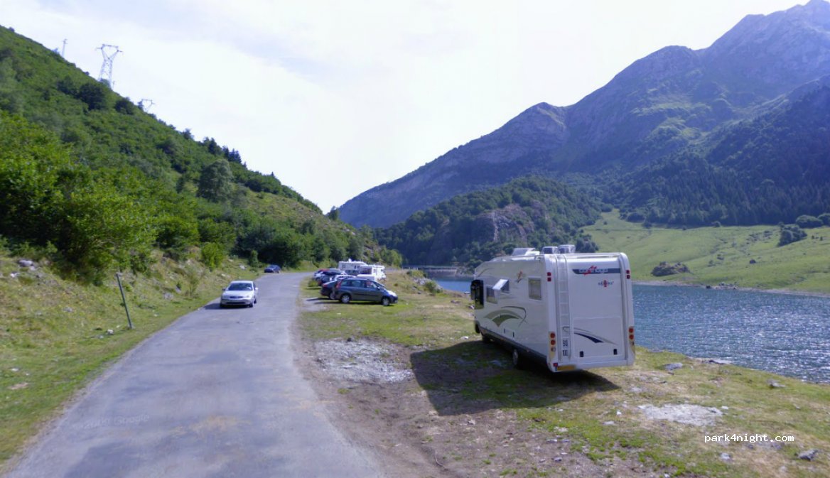
I started the hike going anti clockwise, hiking up steep, slippery terrain due to the bad weather we had the night before. Lac du Tech is at 1200m altitude, so we were in the clouds through the night and had some pretty bad thunderstorms again, a real contrast from the heatwave the week before but I am not complaining, I certainly prefer the British weather.
Going up the route, I had Ellies poles on my rucksack and decided to give them a whirl. I've never actually properly used poles whilst hiking and kind of always believed they were for the elder generation...well I was wrong! They are in fact a cheat code. I stuck to a fast pace getting my heart rate pumping and only briefly stopping to admire the Jurassic park-esque view.

After a couple km in I approached 1500m altitude, and I did in fact come across some wild animals staring at me trying to gain Alpha dominance. It wasn't however the velociraptors I had imagined it was wild Pyrenees cows, blocking my route in the hundreds. There are warning about cows in the Pyrenees, stay clear by 10m. I stood there for about 5 minutes plotting my route, 'how can I get through these cows which out being trampled on, or spiked by their MASSIVE horns?' To the right of the route is what looked like 3 mothers lay down, to the left about 40 cows all staring at me and what looked like a route through the middle of both, 'Is this a good idea?' I asked myself, I'm alone, clear cliff faces on either side of the herd. then I notice a calf right in the middle of the path in between , what I guess is the mothers and the rest of the heard. ‘Nope definitely not a good idea.’

I am not giving up this easy though, I am feeling good and enjoying the hike. I don't often go solo hiking, sometimes I get inside my own head and end up in a dark place or even just tell myself I can't do it even when I’ve done 100s of harder routes in the past, but this time I was loving life. So I look at my map and my GPS and I know the route is a lolly-pop loop. I survey the contour lines on the GPS and map and see that I could possibly get down and cross the river separating the Western and Eastern sides of the trail.
After making my decision I head down to the river, it’s about a 150m loss in elevation getting down to it and I repeat to myself in my head, 'Don't do anything stupid it’s only a little hike, if something feels sketchy just turn around and go back to the van'. As I approached the river the terrain became steeper, but I still felt relatively safe. I could see a route up to the other trail on the other riverbank and what looked like a safe crossing over the river.
The crossing was complete, and I was on the eastern trail, the route back, and feeling good about myself I stomped on to the Cabane. Finally coming around the back of where the cows were blocking my path I could see a few of the herd on the cliff face. 'F U cows I win' I said...

I spoke to soon I turned around and there was another herd of cows...Karma for being a cocky ginger git, I suppose.

Luckily, this time these cows were much easier to pass, so I followed my GPS course to the goal of Le Cabane. Before I got back on track I had another river crossing passed a miniature dam, Structures like this always blow my mind 1600m up in the mountains with no clear path up. It must have been hard graft building it, and I’m moaning about a few cows on a short hike!

As I get passed the river and back on track, I couldn't believe my eyes, about 50 Marmot's running across the field, calling to each other that danger is approaching! I took some videos to send to Ellie as she had wanted to see Marmot's, I kind of felt bad, I am up here having fun and in amazement watching Marmot's run around, a creature I had hardly even heard of a week ago.

Once passed the Velociraptors and Spinosaurus'...I mean cows and Marmots, the valley opened up, it was probably one of the most impressive valleys I have ever seen. Most of the day had been cloud and drizzle and for a brief minute, alpine ridges and summits opened up and I was astonished. I'm in my happy place, not to hot, not to cold, not to wet and not been eaten yet!
As I made my way up the last hill I approach Le cabane, a small bothy building in the middle of the Valley, used by climbers as a refuge en route up to the 3000m summits to the east of the valley. Although I was happy, I was hoping my climber partner would show up with ropes and gear ready to climb. Not to be this time though, and I had no phone signal and told Ellie id be back in 3 and half hours latest.
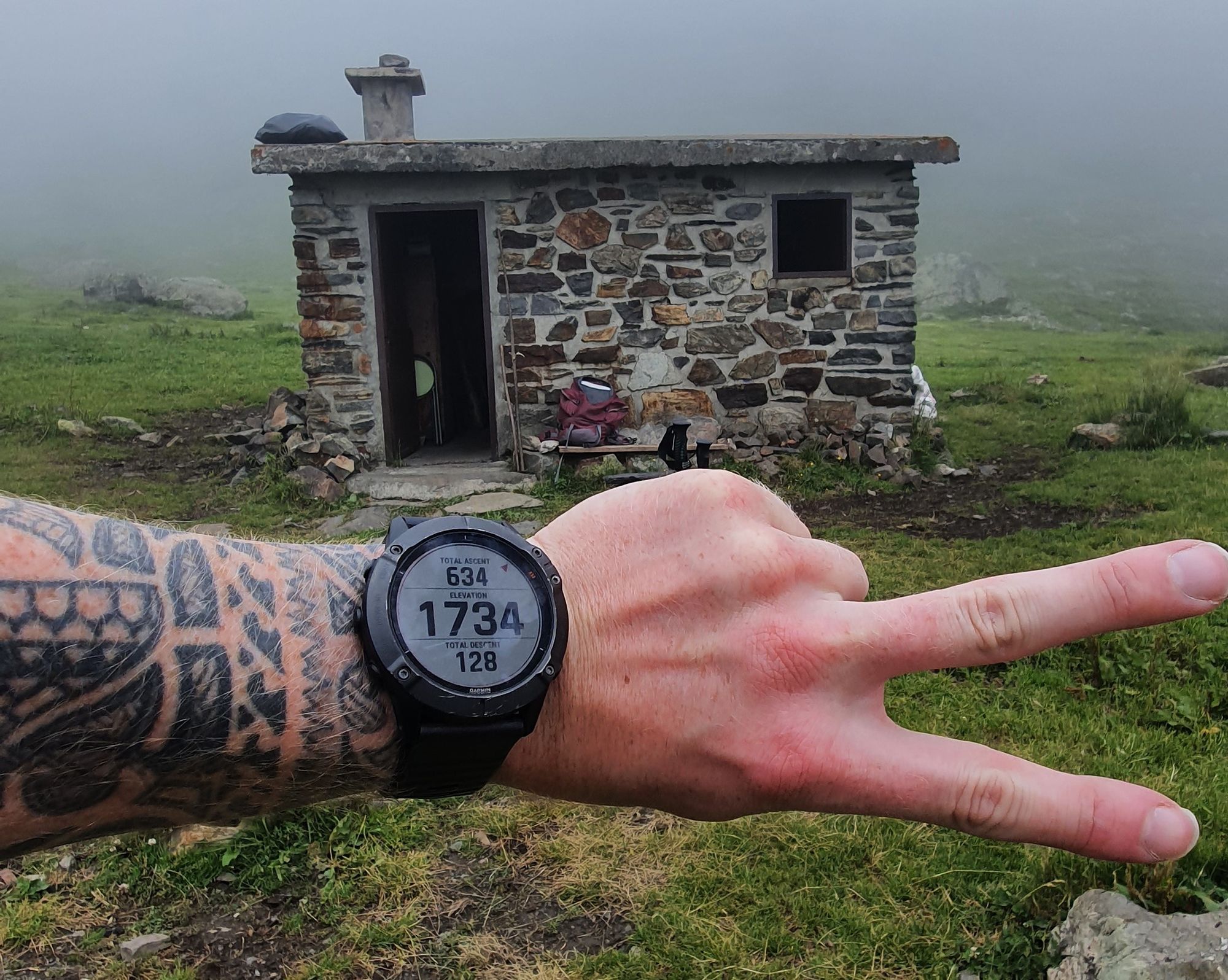
At Le Cabane there was a parent and child in sleeping bags enjoying their day...I apologise for scaring you with my huffing and puffing. 'Bonjour'. Le cabane is at 1734m so I took my rucksack off , enjoyed some Fanta Lemon and the standard baguette and admired the view which kept appearing behind the clouds for about 10 seconds or so and started to think about my way down... 'I hope them bloody cows aren't in the path'.

The weather had gotten worse, so I threw on my rain coat and hat, and had decided I was going to run down most of the route. I had my b2s on, I am getting myself accustomed to wearing stiffened boots for Monte Rosa. I would of worn my B3s but I think that would be a little too over the top for this one. I had an hour or so before Ellie started to panic, and I had the detour around the cows on the way up. So, I needed to get down quickly but safely as I hadn't had phone signal for a while. I sent a quick text to Ellie 'I have no signal and the time is now 13:50 and I am on way down, expected ETA 15:15-30' Just in case she got worried and called mountain rescue.

I ran down the route, keeping good pace, passed the Marmot field and back to the dam where I crossed the river on the way up. Then I see them again, cows! Bane of my life today them bloody cows and their massive bells! I spotted a crossing further downstream and got across making my way through the cows. I walked slowly passed, not to startle them and got well away. I began to run again approaching the forest I had come through after the first river crossing, to avoid the cows early in the day.
I was jogging slowly looking at my GPS as I approached 2 forking trails, one blatant and another quiet faint. I headed up the blatant one, as I remember the trail being really obvious on the way up. As I was going down the trail, I was next to a granite slab of rock and thinking to myself ‘I don't remember that.’ (I am nerd that always looks at rock, not for its geographical history, more because I want to climb it) so I would of noticed it, surely. That is when I spotted some pink rope tied up between 2 trees, 'that's weird'. it was like thin rope hanging between the trees for no reason whatsoever.
I look at my GPS and realise I have gone off course slightly so I turn round and head down the faint path, again I head down here GPS is saying off course, but there is no other path and then I spot that weird pink rope again... with the clouds rolling in and the weather getting worse I think, 'This is turning into hill have eyes this is' after scurrying down a slippery, leaf riddled slope, I finally find my way back to the path I was on, on the way up.
I definitely got into my head this time. Not for any other reason but remembering watching the film 'hills have eyes' as a teenager and absolutely bricking it for a couple weeks after. The path wasn't safe to run, it was slippery, and a slope with a sheer drop to the side of me, so I power walked out of there and as soon as the path opened up I RAN, poles in hand and Usain bolted it out of that forest!
I thought that was the end of it then I come across that pink rope AGAIN, but this time over the path. I thought to myself I'm not going back over the river to the other trail or going back through that forest I am going over it! I went over it then the mind tricks started again...'What's in here, Hill have eyes? Bear? Bulls?'. I came to terms with the fact that farmers have probably put the rope up to stop the cows getting down to the road, and I think if I was with anyone on this hike this would of been quickly swept under the carpet with a pretty reasonable explanation. But that didn't stop my mind going wild.
After what felt like the longest 15minutes of my life, I made it back down to the road, I survived and I got down for 14:40. 50 minutes I dropped 650m of elevation, funny how efficient you are when you thinking your being chased by forest creatures ay! Although eventful, I enjoyed myself. I finished the hike and gained 650m elevation, a detour, avoided cows and got to my destination safely in an hour and 15 minutes, as a bonus my Garmin GPS had told me that I was now acclimatised to 1500m, only an extra 3100m in 2 weeks needed for Monte Rosa!